June 18, 20
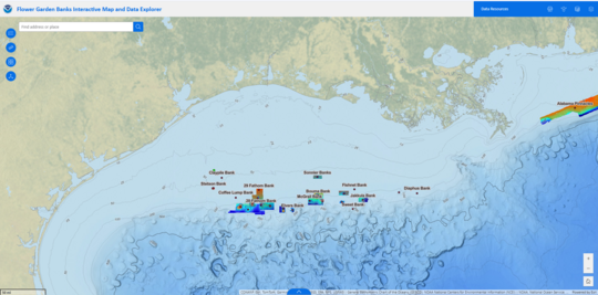
The Flower Garden Banks National Marine Sanctuary (FGBNMS) mapping tool, located on the homepage of the FGBNMS website, recently was upgraded to become an interactive map. This updated online GIS-based mapping tool hosts data layers for bathymetry, management zones, oil and gas activities, mooring buoys, and oceanographic data in and around the sanctuary. Numerous data layers can be turned on or off (via the stacked square icon at the top right-hand corner of the map) and other external data can be added to the map. In addition, FGBNMS dashboards (such as the Sofar Spotter Buoy Dashboard) can be found on the “Data Resources” link in the top blue box of the mapping tool. As a bonus, a new FGBNMS mooring buoy data layer provides buoy status information (present or not present) so that stakeholders can stay updated as they plan offshore trips.
 |
|
Before you head out to Flower Garden Banks National Marine Sanctuary, get the most up-to-date information available about weather, sea state, and water conditions.
|
|
 |
|